 琉球列島地形復元
 沖縄地理21号投稿論文
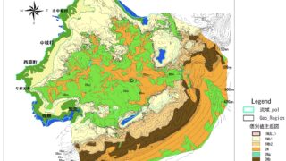
沖縄島中南部の地形形成と中城湾沖縄地理21号 , p1-16「中城湾海底地形地質調査報告」(海上保安庁水路部 1985)等のGISデータ化と解析より,沖縄島中南部の地形,中城湾の形成プロセスを明らかにした.中城湾海底下,沖積層により埋め立てられた古中城川は,氷期低海水準期に島尻層群が露出する丘陵に発達した河川であった....
琉球列島地形復元  琉球列島地形復元
  琉球列島地形復元
  琉球列島地形復元
  琉球列島地形復元